Navigatsioonisüsteem Geotrack Explorer Plus GPS/GNSS tüübi jaoks ratastraktori


Kui olete otsustanud osta madala hinnaga tehnikat, veenduge, et suhtlete tegeliku müüjaga. Uurige välja võimalikult palju infot tehnika omaniku kohta. Üks petmisviisidest on esineda tegelikult olemasoleva ettevõtte nime all. Kahtluste tekkimise korral teatage sellest meile tagasisidevormi kaudu, et saaksime asja täiendavalt kontrollida.
Enne ostu sooritamist uurige hoolikalt erinevaid müügipakkumisi, et selgitada välja teie poolt valitud tehnika mudeli keskmine hind. Kui teie valitud müügipakkumise hind on oluliselt madalam sarnaste pakkumiste hindadest, olge ettevaatlik. Suur hinnaerinevus võib viidata varjatud defektidele või müüja petmiskatsele.
Ärge ostke kaupa, mille hind erineb tunduvalt analoogse tehnika keskmisest hinnast.
Ärge nõustuge kahtlaste tagatis- ja ettemaksudega. Kahtluste korral ärge kartke täpsustada üksikasju, küsige müüdava tehnika lisafotosid ja dokumente, kontrollige dokumentide ehtsust, esitage lisaküsimusi.
See on kõige levinum petmise viis. Ebaausad müüjad võivad küsida teatud ettemaksusummat, et „broneerida“ teile tehnika ostmise õigus. Sel moel võivad petised koguda suure rahasumma ja seejärel kaduda, nii et nendega pole enam võimalik ühendust võtta.
- Ettemaksu kandmine kaardile
- Ärge makske ettemaksu, vormistamata dokumente, mis tõendavad raha üleandmise akti, kui teil tekib müüjaga suhtlemisel kahtlusi.
- Raha kandmine „vahendaja“ kontole
- Selline palve peab tegema ettevaatlikuks; tõenäoliselt suhtlete kelmiga.
- Raha kandmine sarnase nimega ettevõtte kontole
- Olge tähelepanelikud, kelmid võivad esineda tuntud ettevõtete nimel, tehes ettevõtte nimes väikeseid muudatusi. Ärge kandke raha üle, kui ettevõtte nimi tekitab kahtlusi.
- Oma pangarekvisiitide märkimine reaalse ettevõtte nimel esitatud arvele
- Enne ülekande tegemist kontrollige, kas arvele märgitud pangarekvisiidid on õiged ja kuuluvad vastavale ettevõttele.
Müüja kontaktid


 Ukraina


AGRICULTURAL GUIDANCE SYSTEM WITH A WIDE SET OF FUNCTIONS AND STABLE ACCURACY USING A FREE SATELLITE SIGNAL. SUPPORT FOR AUTOMATIC SPRAYER SECTION CONTROL. PROFESSIONAL RTK MODE WITH ACCURACY UP TO 2.5 cm.
Forget about the lack of a satellite signal while working and stopping field work. With the new and state-of-the-art GM SMART GNSS receiver, your navigation system for agricultural machinery will always be up and running. Thanks to simultaneous work with satellite systems GPS, GLONASS, GALILEO, BEIDOU you will always have enough satellites for uninterrupted work in the field. The average number of satellites in operation - 35-40 satellites.
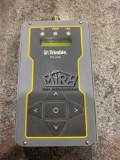
The geotrack explorer PLUS has embedded "GEOTRACK" software, which provides accuracy of 15 cm from pass-to-pass, and the ability to connect to RTK and obtain an accuracy of 1-3 cm. Geotrack explorer PLUS display has a shockproof enclosure, and a completely sealed monitor from dust and moisture.
Using the navigation system for agricultural machinery will allow you to easily solve a number of problems, including: accurate control of machinery in the field, measurement of agricultural land, reducing the number of workers for field work, the ability to work in poor visibility (night, fog, dust); saving time, significantly reducing the cost of fuel, fertilizers, plant protection products and herbicides. During operation, the tips on the screen of the navigation system help to ensure accurate driving, preventing the appearance of untreated areas (flaws) and areas of double treatment (overlaps).
The GeoTrek Explorer PLUS navigation system has a 7-inch (17.8 cm) high-brightness screen that is easy to read even on a bright sunny day. High screen resolution allows you to see a clearer picture. Visual night mode is provided. The display has shock protection and is protected from dust and moisture. The set includes a reliable vibration-resistant metal RAM mount and a docking station.
Equipment:
Rugged monitor geotrack explorer plus 7" (17,8 cm)
GNSS/RTK receiver GM Smart
Docking station with RS232
RAM mount
Cables
User manual, warranty card and other documents
Strength characteristics:
Dust and moisture protection: IP67
Vibration resistance consistency: MIL-STD-810G
Gravity drop resistance test: 150 cm
Functionality:
Accurate guidance from pass-to-pass
Accurate area measurement
Treatment of saved fields
Determining the treated area
Visualization of the treated area
Displaying the movement speed
Displaying azimuth
Five guidance patterns
Adjustment of width of equipment (to centimeters)
Online technical support
Saving a field map
Automatic saving works
Specifying Job Types (sowing, spraying, etc.)
Support for RTK L1
Optional support for RTK L1/L2
Online sync with Agroprofile
Operating modes:
Area measurement
Area measurement with offset
Free guidance mode
Straight A-B
Curve A-B
Perimeter - Straight A-B
Perimeter - Curve A-B
Cloud opportunities:
Synchronization of field areas
Synchronization of scheduled works
Displaying works on the map
Online view of performing works in the fields
Entering the types of work
Quality control of works (% of overlapping)
Time spent doing work
What data is displayed while driving:
Treated area
Travelled length
Speed of movement
Number of satellites
Satellite signal quality (HDOP)
Visual guidance tips
Calculation of working time
Count overlapping
Visualization of overlapping
Ratio: work done / in process
Supported languages: English, Italian, French, German, Spanish, Portuguese, Estonian, Ukrainian, Russian, Polish, Hungarian, Hindi, Arabian
Product page: kuva kontaktid